-
AidData’s Chinese Official Finance in Three Ecologically Sensitive Areas, Level 1, Version 1.01
 កម្ពុជា, ឡាវ, មីយ៉ាន់ម៉ា, ថៃ, វៀតណាម
31 មករា 2017
ប្រភព: BenYishay, Ariel, Bradley Parks, Daniel Runfola, Rachel Trichler....
This is the 1.0.1 version of the Level 1 product, of a sub-nationally georeferenced dataset of Chinese official finance activities between 2000 and 2014 in three ecologically...
កម្ពុជា, ឡាវ, មីយ៉ាន់ម៉ា, ថៃ, វៀតណាម
31 មករា 2017
ប្រភព: BenYishay, Ariel, Bradley Parks, Daniel Runfola, Rachel Trichler....
This is the 1.0.1 version of the Level 1 product, of a sub-nationally georeferenced dataset of Chinese official finance activities between 2000 and 2014 in three ecologically...
-
Airports of Vietnam
វៀតណាម
1 កក្កដា 2016
ប្រភព: Global Map of Vietnam ©ISCGM/ Department of Survey and Mapping,...
A geospatial point dataset containing all known airports in Vietnam. It contains geospatial coordinates, object code, name, city, type, ICAO and IATA code .
-
បណ្តាញផ្លូវ និងផ្លូវដែក និងដង់ស៊ីតេផ្សារ
កម្ពុជា
4 តុលា 2015
ប្រភព: គណៈកម្មាធិការជាតិសម្រាប់ការអភិវឌ្ឍតាមបែបប្រជាធិបតេយ្យនៅថ្នាក់ក្រោមជ...
 ប្រព័ន្ធទិន្នន័យឃុំ/សង្កាត់នេះ ត្រូវបានបង្កើតឡើងដោយ គណៈកម្មាធិការសម្រាប់ការអភិវឌ្ឍតាមបែបប្រជាធិបតេយ្យនៅថ្នាក់ក្រោមជាតិ (គ.ជ.អ.ប)។ ទិន្នន័យដែលដកស្រង់ចេញពីប្រព័ន្ធទិន្នន័យនេះមាន៖ ...
-
Railway station of Vietnam
វៀតណាម
1 កក្កដា 2016
ប្រភព: Global Map of Vietnam ©ISCGM/ Department of Survey and Mapping,...
A geospatial point dataset containing all known railway stations in Vietnam. It contains geospatial coordinates, object code, station's name.
-
ផែនទីការរៀបចំផែនការប្រើប្រាស់ដីធ្លីថ្នាក់ឃុំនៃខេត្តពោធិ៍សាត់ (CLUP) ឆ្នាំ ២០០៩
កម្ពុជា
18 មេសា 2017
ប្រភព: ក្រសួងរៀបចំដែនដី នគរូបនីយកម្ម និងសំណង់...
 ផែនទីការរៀបចំផែនការប្រើប្រាស់ដីធ្លីថ្នាក់ឃុំនៃខេត្តពោធិ៍សាត់ (CLUP)៖ សង្កាត់ចំរើនផល ឃុំក្បាលត្រាច ឃុំមេទឹក ឃុំផ្ទះរុង ឃុំព្រងិល សង្កាត់រលាប ឃុំតាល...
-
ផែនទីការរៀបចំផែនការប្រើប្រាស់ដីធ្លីថ្នាក់ឃុំនៃខេត្តកោះកុង (CLUP) ឆ្នាំ ២០០៩
កម្ពុជា
18 មេសា 2017
ប្រភព: ក្រសួងរៀបចំដែនដី នគរូបនីយកម្ម និងសំណង់...
 ផែនទីការរៀបចំផែនការប្រើប្រាស់ដីធ្លីថ្នាក់ឃុំនៃខេត្តកោះកុង (CLUP)៖ ឃុំអណ្តូងទឹក ឃុំជ្រោយប្រស់ សង្កាត់ស្មាច់មានជ័យ សង្កាត់ស្ទឹងវែង ឃុំថ្មស និងឃុំត្រពា...
-
ផែនទីការរៀបចំផែនការប្រើប្រាស់ដីធ្លីថ្នាក់ឃុំនៃខេត្តរតនគិរី (CLUP) ឆ្នាំ ២០០៩
កម្ពុជា
18 មេសា 2017
ប្រភព: ក្រសួងរៀបចំដែនដី នគរូបនីយកម្ម និងសំណង់...
 ផែនទីការរៀបចំផែនការប្រើប្រាស់ដីធ្លីថ្នាក់ឃុំនៃខេត្តរតនគិរី (CLUP)៖ ឃុំឯកភាព ឃុំកាចូន ឃុំប៉ុង ឃុំសាមគ្គី ឃុំសិរីមង្គល និងឃុំតឺន គឺជាការរៀបចំផែនកា...
-
ផែនទីការរៀបចំផែនការប្រើប្រាស់ដីធ្លីថ្នាក់ឃុំនៃខេត្តសៀមរាប (CLUP) ឆ្នាំ ២០០៩
កម្ពុជា
18 មេសា 2017
ប្រភព: ក្រសួងរៀបចំដែនដី នគរូបនីយកម្ម និងសំណង់...
 ផែនទីការរៀបចំផែនការប្រើប្រាស់ដីធ្លីថ្នាក់ឃុំនៃខេត្តសៀមរាប (CLUP)៖ ឃុំចាន់ស ឃុំដូនពេង ឃុំលាងដៃ ឃុំនគរភាស ឃុំពពេល ឃុំស្រែខ្វាវ ឃុំស្វាយចេក និងឃុំតា...
-
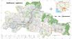
ផែនទីការរៀបចំផែនការប្រើប្រាស់ដីធ្លីថ្នាក់ឃុំនៃខេត្តកំពង់ស្ពឺ (CLUP) ឆ្នាំ ២០០៩
កម្ពុជា
29 មីនា 2017
ប្រភព: ក្រសួងរៀបចំដែនដី នគរូបនីយកម្ម និងសំណង់...
ផែនទីការរៀបចំផែនការប្រើប្រាស់ដីធ្លីថ្នាក់ឃុំនៃខេត្តកំពង់ស្ពឺ (CLUP)៖ ឃុំគិរីវន្ដ ឃុំមហាសាំង ឃុំមនោរម្យ ឃុំប្រាំបីមុំ ឃុំព្រៃក្មេង និងឃុំយាអង្គ គឺជាការ...
-
ផែនទីការរៀបចំផែនការប្រើប្រាស់ដីធ្លីថ្នាក់ឃុំនៃខេត្តកំពង់ចាម (CLUP) ឆ្នាំ ២០០៩
កម្ពុជា
18 មេសា 2017
ប្រភព: ក្រសួងរៀបចំដែនដី នគរូបនីយកម្ម និងសំណង់...
 ផែនទីការរៀបចំផែនការប្រើប្រាស់ដីធ្លីថ្នាក់ឃុំនៃខេត្តកំពង់ចាម (CLUP)៖ ឃុំជីគរ ឃុំមង់រៀវ ឃុំរអាង និងឃុំស្រក គឺជាការរៀបចំផែនការប្រើប្រាស់ដីធ្លីថ្នាក់ឃុ...
-
ផែនទីការរៀបចំផែនការប្រើប្រាស់ដីធ្លីថ្នាក់ឃុំនៃខេត្តមណ្ឌលគិរី (CLUP) ឆ្នាំ ២០០៩
កម្ពុជា
18 មេសា 2017
ប្រភព: ក្រសួងរៀបចំដែនដី នគរូបនីយកម្ម និងសំណង់...
 ផែនទីការរៀបចំផែនការប្រើប្រាស់ដីធ្លីថ្នាក់ឃុំនៃខេត្តមណ្ឌលគិរី (CLUP)៖ ឃុំដាក់ដាំ ឃុំពូជ្រៃ ឃុំសែនមនោរម្យ ឃុំស្រែអំពូម ឃុំស្រែខ្ទុម និងឃុំស្រែព្រះ...
-
ផែនទីការរៀបចំផែនការប្រើប្រាស់ដីធ្លីថ្នាក់ឃុំនៃខេត្តព្រះសីហនុ (CLUP) ឆ្នាំ ២០០៩
កម្ពុជា
18 មេសា 2017
ប្រភព: ក្រសួងរៀបចំដែនដី នគរូបនីយកម្ម និងសំណង់...
ផែនទីការរៀបចំផែនការប្រើប្រាស់ដីធ្លីថ្នាក់ឃុំនៃខេត្តព្រះសីហនុ (CLUP)៖ ឃុំអណ្តូងថ្ម ឃុំកំពេញ ឃុំអូរត្រេះ ឃុំសំរុង និងឃុំទំនប់រលក គឺជាការរៀបចំផែនកា...
-
ផែនទីការរៀបចំផែនការប្រើប្រាស់ដីធ្លីថ្នាក់ឃុំនៃខេត្តកែប (CLUP) ឆ្នាំ ២០០៩
កម្ពុជា
18 មេសា 2017
ប្រភព: ក្រសួងរៀបចំដែនដី នគរូបនីយកម្ម និងសំណង់...
ផែនទីការរៀបចំផែនការប្រើប្រាស់ដីធ្លីថ្នាក់ឃុំនៃខេត្តកែប (CLUP)៖ ឃុំអង្កោល ឃុំអូរក្រសារ និងឃុំពងទឹក គឺជាការរៀបចំផែនការប្រើប្រាស់ដីធ្លីថ្នាក់ឃុំដែលបាន...
-
ផែនទីការរៀបចំផែនការប្រើប្រាស់ដីធ្លីថ្នាក់ឃុំនៃខេត្តក្រចេះ (CLUP) ឆ្នាំ ២០០៩
កម្ពុជា
18 មេសា 2017
ប្រភព: ក្រសួងរៀបចំដែនដី នគរូបនីយកម្ម និងសំណង់...
 ផែនទីការរៀបចំផែនការប្រើប្រាស់ដីធ្លីថ្នាក់ឃុំនៃខេត្តក្រចេះ (CLUP)៖ ឃុំដារ ឃុំក្បាលដំរី ឃុំអូរគ្រៀង ឃុំឫស្សីកែវ ឃុំសោប ឃុំស្រែចារ ឃុំស្វាយជ្រះ និងឃុ...
-
Urban design principles for flood resilience: Learning from the ecological wisdom of living with floods in the Vietnamese Mekong Delta
វៀតណាម
29 ធ្នូ 2017
ប្រភព: Kuei-Hsien Liao, Tuan Anh Le, Kien Van Nguyen (2016). Urban design...
Despite the widespread implementation of flood control infrastructure, modern cities around the world remain vulnerable to flood hazards. Although flood management has in...
-
Infrastructure investment needs in the Lower Mekong 2010-2020
កម្ពុជា, ឡាវ, មីយ៉ាន់ម៉ា, ថៃ, វៀតណាម
16 មេសា 2016
ប្រភព: Asian Development Bank Institute, Working Paper No....
Dataset created from an ADB Institute document to show the annual infrastructure investment required for each Lower Mekong country from 2010-2020. It also indicates the...
-
Greater Mekong Subregion Economic Corridors 2012
កម្ពុជា, ចិន, ឡាវ, មីយ៉ាន់ម៉ា, ថៃ, វៀតណាម
9 កក្កដា 2015
ប្រភព: Asian Development Bank / Environment Operations Center...
A dataset containing trans-boundary roads declared Greater Mekong Subregion transport corridors and their status as of 2012 -- existing, planned, potential.
-
ADB infrastructure-related projects 2005-2015
កម្ពុជា, ឡាវ, មីយ៉ាន់ម៉ា, ថៃ, វៀតណាម
16 មេសា 2016
ប្រភព: Asian Development Bank. Project Records.
http://www.adb.org/projects/
A summary of the number of infrastructure related projects approved by the ADB in Lower Mekong countries from 2005-2015. Collated for an interactive visualization on the OD...
-
Airports of Myanmar
មីយ៉ាន់ម៉ា
27 កក្កដា 2015
ប្រភព: Environment Operations Centre (www.gms-eoc.org) based on Open...
Airport locations in Myanmar including attributes (name, type ICAO and IATA code).