-
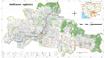
Siem Reap communal land use planning (CLUP) atlas 2009
 Cambodia
April 18, 2017
Source: Ministry of Land Management, Urban Planning and Construction...
Cambodia
April 18, 2017
Source: Ministry of Land Management, Urban Planning and Construction...
 Siem Reap communal land use planning(CLUP) atlas (Chan Sar, Doun Peaeng, Leang Dai, Nokor Pheas , Popel, Srae Khvav, Svay Chek, Tayaek commune) is communal land use planning ext...
-
Kampong Speu commune land use planning (CLUP) atlas 2009
Cambodia
March 29, 2017
Source: Ministry of Land Management, Urban Planning and Construction...
Kampong Speu commune land use planning(CLUP) atlas (Kiri Vaon, Moha Sang, Honorom, Prabei Mom, Prey Khmeng, and Yea Angk commune) is communal land use planning extracted from 20...
-
Kampong Cham communal land use planning (CLUP) atlas 2009
Cambodia
April 18, 2017
Source: Ministry of Land Management, Urban Planning and Construction...
 Kampong Cham communal land use planning(CLUP) atlas (Chikor, Moung Riev, Roang, and Srak commune) is communal land use planning extracted from 2009 contained both detailed curre...
-
Mondulkiri communal land use planning (CLUP) atlas 2009
Cambodia
April 18, 2017
Source: Ministry of Land Management, Urban Planning and Construction...
 Mondulkiri communal land use planning(CLUP) atlas (Dak Dam, Pu Chri, Saen Monourom, Srae Ampum, Srae Khtum, and Srae Preah commune) is communal land use planning extracted from ...
-
Preah Sihanouk communal land use planning (CLUP) atlas 2009
Cambodia
April 18, 2017
Source: Ministry of Land Management, Urban Planning and Construction...
Preah Sihanouk communal land use planning(CLUP) atlas (Angdoung Thma, Kampenh, Outreh, Samrong, and Tomnob Rolok commune) is communal land use planning extracted from 2009 conta...
-
Kep communal land use planning (CLUP) atlas 2009
Cambodia
April 18, 2017
Source: Ministry of Land Management, Urban Planning and Construction...
Kep communal land use planning(CLUP) atlas (Angkaol, Ou Krasar, and Pong Tuek commune) is communal land use planning extracted from 2009 contained both detailed current land us...
-
Kratie communal land use planning (CLUP) atlas 2009
Cambodia
April 18, 2017
Source: Ministry of Land Management, Urban Planning and Construction...
 Kratie communal land use planning(CLUP) atlas (Dar, Kbal Damrey, O Krieng, Ruessei Kaev, Saob, Srae Char, Svay Chreah, and Thmi commune) is communal land use planning extracted ...
-
Percent forest cover by province in Cambodia (1973 - 2014)
Cambodia
April 1, 2015
Source: Open Development Cambodia. "Forest cover in Cambodia (1973 -...
The dataset describes percent forest cover by province in Cambodia in 1973, 1989, 2000, 2004, 2009, 2013 and 2014. This dataset is derived from ODC forest cover in Cambodia (197...
-
Plant and animal species in Prey Lang
Cambodia
November 7, 2016
Source: Prey Lang Community Network http://preylang.net/
Winrock...
This data consist of information about species of plants and animals living in Prey Lang forest according to Biodiversity Assessment of Prey Lang published in 2015. Those inform...
-
LMCs - Key Dimensions of Water Security (ADB - ADWO)
Cambodia, Lao People's Democratic Republic, Myanmar, Thailand, Viet Nam
May 17, 2018
Source: ABD:...
Data on the LMCs on Key Dimensions of Water Security, developed by ADB.
-
WASH Dataset 1990-2015
Cambodia, Lao People's Democratic Republic, Myanmar, Thailand, Viet Nam
May 10, 2018
Source: ESCAP SDG data portal and JMP Data Portal.
Contains data compiled by JMP and UNESCAP on SDGs 6.1 and 6.2, including safely managed drinking water, basic hand washing facilities, safely managed sanitation, and open defeca...
-
LMCs Protected Areas Data (Protected Areas Program - UNEP)
Cambodia, Lao People's Democratic Republic, Myanmar, Thailand, Viet Nam
May 15, 2018
Source: The April 2016 version of the World Database on Protected Areas...
Summary statistics, per country, for the extent of area covered by protected areas for both terrestrial and marine realms. LMCs only.
-
Agreements Document Type
Cambodia, Lao People's Democratic Republic, Myanmar, Thailand, Viet Nam
February 20, 2017
Source: Agreements document type is determined by the ODM team.
Data used for dropdown options in the Agreements metadata forms. Definitions of each term is provided and also available within the Partner wiki https://wiki.opendevelopmentmeko...
-
Urban population projections in the Lower Mekong
Cambodia, Lao People's Democratic Republic, Myanmar, Thailand, Viet Nam
March 26, 2018
Source: United Nations, Department of Economic and Social Affairs,...
Data is derived from country census complied by the United Nations, Department of Economic and Social Affairs, Population Division. The suggested citation of the original report...
-
The state of the world's children report 2015 statistical tables
Cambodia, China, Lao People's Democratic Republic, Myanmar, Thailand, Viet Nam
July 31, 2015
Source: Unicef. “State of the world's children report 2015, statistical...
UNICEF's most recent key statistics on child survival, development and protection for the world’s countries, areas and regions. The statistical tables in this volume support UNI...
-
Proportion of Urban Population Living in Slums
Cambodia, Lao People's Democratic Republic, Myanmar, Thailand, Viet Nam
March 6, 2018
Source: United Nations Statistics Division
On 1 January 2016, the world officially began implementation of the 2030 Agenda for Sustainable Development—the transformative plan of action based on 17 Sustainable Development...
-
Population density from 1995 to 2000 Thailand, Myanmar, Laos, Vietnam and Cambodia
Cambodia, China, Lao People's Democratic Republic, Myanmar, Thailand, Viet Nam
June 22, 2015
Source: World Data Bank (CSV file) and CartoDB (PNG file)
Population density of Thailand, Myanmar, Laos, Cambodia, and Vietnam based on data from the World Data Bank. This dataset also includes a visualization of the data using CartoDB...
-
Infrastructure investment needs in the Lower Mekong 2010-2020
Cambodia, Lao People's Democratic Republic, Myanmar, Thailand, Viet Nam
April 16, 2016
Source: Asian Development Bank Institute, Working Paper No....
Dataset created from an ADB Institute document to show the annual infrastructure investment required for each Lower Mekong country from 2010-2020. It also indicates the percenta...
-
Special Economic Zones & Cross Border Economic Zones in the Mekong
Cambodia, China, Lao People's Democratic Republic, Myanmar, Thailand, Viet Nam
June 26, 2015
Source: Asian Development Bank Environment Operations Center (www.gms-eoc.org).
A geospatial dataset describing SEZ and CBEZ of the Greater Mekong Subregion. It contains 416 SEZ and CBEZ including attributes (name, type, country and code).
-
Agriculture land areas 2012
Cambodia, China, Lao People's Democratic Republic, Myanmar, Thailand, Viet Nam
June 22, 2016
Source: ADB's Statiscal Database.
https://sdbs.adb.org/sdbs/...
Comparison of agriculture land with permanent crops, pasture or meadow in 2012 for the Lower Mekong countries. Collated for a visualization on the OD Mekong Land page: https://o...