-
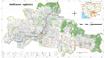
ELC and SEZ and Roads
 Cambodia
December 6, 2015
Source: Save Cambodia's Wildlife. Atlas of Cambodia: maps on...
Cambodia
December 6, 2015
Source: Save Cambodia's Wildlife. Atlas of Cambodia: maps on...
 This dataset provides known locations of Economic Land Concessions, Special Economic Zones and national level roads. It was compiled from the Economic Census of Cambodia (2011),...
-
National grid, import of energy, consumption of energy, hydro-electric dams
Cambodia
December 6, 2015
Source: Ministry of Industry, Mines and Energy, Department of Geography:...
 The dataset provides location of national electricity grid, hydropower dam locations, and energy import and consumption rates. Data were provided to ODC in vector format by Save...
-
Prey Lang protected forest and biodiversity conservation area
Cambodia
December 6, 2015
Source: Open Development Cambodia, contact@opendevcam.net, +855 23 221...
 This dataset shows the proposed boundary of the Prey Lang protected forest and biodiversity conservation area. The data was collected from many sources by ODC’s mappers such as ...
-
Prek Toal bird sanctuary biosphere reserve
Cambodia
December 6, 2015
Source: Save Cambodia's Wildlife. In Atlas of Cambodia: maps on...
 The Prek Toal Bird Sanctuary Biosphere Reserve is represented in this dataset. Dataset provided to Open Development Cambodia (ODC) by Save Cambodia's Wildlife's Atlas Working Gr...
-
Oddar Meanchey REDD+
Cambodia
December 6, 2015
Source: Pact Cambodia (2013) http://www.pactcambodia.org/
Aruna...
 This dataset represents the community forest boundaries that combine to form the Oddar Meanchey REDD+ initiative. Data were provided to ODC by Save Cambodia's Wildlife's Atlas W...
-
Oil & gas blocks and mining
Cambodia
December 6, 2015
Source: Save Cambodia's Wildlife. Atlas of Cambodia: maps on...
 These combined dataset provides information on the location of oil and gas blocks as well as mining concessions. Data were provided to ODC by Save Cambodia's Wildlife's Atlas Wo...
-
Phnom Penh urban sprawl timeline (2003-2013)
Cambodia
December 6, 2015
Source: Landsat NASA 2003/13 http://landsat.gsfc.nasa.gov/
 Landsat satellite images are presented in this dataset of Phnom Penh detailing land use change in the year 2003 and 2013. Dataset were provided to Open Development Cambodia (ODC...
-
Pursat communal land use planning (CLUP) atlas 2009
Cambodia
April 18, 2017
Source: Ministry of Land Management, Urban Planning and Construction...
 Pursat communal land use planning(CLUP) atlas (Chamraeun Phal, Kbal Trach, Me Tuek, Phteah Rung, Prongil, Roleab, Ta Lou, Tnaot Chum commune) is communal land use planning extra...
-
Koh Kong communal land use planning (CLUP) atlas 2009
Cambodia
April 18, 2017
Source: Ministry of Land Management, Urban Planning and Construction...
 Koh Kong communal land use planning(CLUP) atlas (Andong Tuek, Chrouy Pras, Smach Mean Chey, Stung Veng, Tma Sa, and Trapeang Rung commune) is communal land use planning extracte...
-
Ratanakiri communal land use planning (CLUP) atlas 2009
Cambodia
April 18, 2017
Source: Ministry of Land Management, Urban Planning and Construction...
 Ratanakiri communal land use planning(CLUP) atlas (Aekakpheap, Ka Choun, Pong, Sameaki, Serei Mongkol, and Toen commune) is communal land use planning extracted from 2009 contai...
-
Siem Reap communal land use planning (CLUP) atlas 2009
Cambodia
April 18, 2017
Source: Ministry of Land Management, Urban Planning and Construction...
 Siem Reap communal land use planning(CLUP) atlas (Chan Sar, Doun Peaeng, Leang Dai, Nokor Pheas , Popel, Srae Khvav, Svay Chek, Tayaek commune) is communal land use planning ext...
-
Kampong Cham communal land use planning (CLUP) atlas 2009
Cambodia
April 18, 2017
Source: Ministry of Land Management, Urban Planning and Construction...
 Kampong Cham communal land use planning(CLUP) atlas (Chikor, Moung Riev, Roang, and Srak commune) is communal land use planning extracted from 2009 contained both detailed curre...
-
Mondulkiri communal land use planning (CLUP) atlas 2009
Cambodia
April 18, 2017
Source: Ministry of Land Management, Urban Planning and Construction...
 Mondulkiri communal land use planning(CLUP) atlas (Dak Dam, Pu Chri, Saen Monourom, Srae Ampum, Srae Khtum, and Srae Preah commune) is communal land use planning extracted from ...
-
Kratie communal land use planning (CLUP) atlas 2009
Cambodia
April 18, 2017
Source: Ministry of Land Management, Urban Planning and Construction...
 Kratie communal land use planning(CLUP) atlas (Dar, Kbal Damrey, O Krieng, Ruessei Kaev, Saob, Srae Char, Svay Chreah, and Thmi commune) is communal land use planning extracted ...
-
Phnom Penh Municipality Public Announcement
 Cambodia
Notification
September 1, 2014
Cambodia
Notification
September 1, 2014
 Phnom Penh Capital Hall released an announcement on the opening public transport service to the publics provided by City Hall’s Phnom Penh City Bus following to the date and lin...